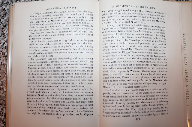
I came across this extremely intriguing story of a possible submerged rock with runes carved into it while reading one of Hjalmar R. Holand's books published in 1946, entitled "America 1355 - 1364." The obscure story is told in Appendix B of the book, in a sub-title called "A Submerged Inscription." The rock's existence was reported in "North Dakota Guide Book," from which the following citation, given by Holand, is taken:
"Below Stanton is DEAPOLIS (caps in the original), marked by a single grain elevator, all that remains of another of the towns that sprang up along the Missouri, flourished, and declined with the steamboat trade...old residents tell the story that in the summer of 1894 the river at Deapolis was extremely low, exposing a huge boulder in the center of the stream. An interested group made their way to the stone, and found it carved with peculiar markings they were unable to decipher. Before leaving, they added the date of their visit to the inscription. Forty years later, the river stage was again low enough to bring the stone above water, and a second party visited it, and found the same undecipherable markings, as well as the carving of the 1894 party."
Holand goes on to cite several reasons why he thinks the rock bears Norse runes. One reason is because in the past Mandan Indians were situated in the exact same spot as where the strange rock is located. Another reason is because the so-called "Verendrye Runestone" was discovered in North Dakota too, and this small stone is thought to possibly have had runes carved into it. Additionally, the local settlers indicated that the inscription was carved, which would further indicate an iron chisel being used, something Native Americans would not have possessed.
It seems possible to me that one of many "half-century droughts" in the past may have exposed the large rock to a medieval-era Norse carver, even before the two later groups of settlers found it exposed by much later droughts. If so, this may reveal a possible medieval Norse/American Indian connection, which could in turn help to explain the peculiar genetic makeup of the Mandan Indians.

http://www.lewisandclarktrail.com/section2/ndcities/BismarckMandan/villagemap.htm
http://www.digitalhorizonsonline.org/digital/collection/uw-ndshs/id/1245


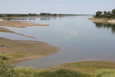
I believe I may have discovered that the described rock may still be in the water, exactly across from where Old Deapolis was situated by the railroad track by the river. On the first trip I made to the area, while using modern equipment, I ended up with a depth finder screen shot of what appears to be a large rock. In other words, sonar found an "anomaly," almost certainly a large boulder, submerged in about 17 feet of water, directly across from the former site of both a Mandan village and the vanished town of Deapolis. The fisherman boat-pilot I hired was somewhat familiar with the bottom of the river in this area and he was surprised to see what appeared to be a large rock, perhaps 3 or so feet high by several feet long, sitting on a ledge near the main channel. The channel was about 22 feet deep at the spot. It's possible that the river was only several feet deep during severe droughts, leaving the rock in a foot or two of water with the shrunken down river flowing in an adjacent channel--perhaps only several feet deep. If the rock was sitting on a ledge in a few feet of water with the main channel flowing next to it, this may have made the rock appear to be in the middle of the river, which was reported.
On this, my first trip, the river was riled by the wind and we were not able to get any good camera images of the apparent rock seen on the depth-finder. I was determined that on my next trip, better camera techniques might be applied to the situation, perhaps using a long pole to reach down with better lighting and a more stable video camera. So, I revisited the site again on October 22nd, 2016, hoping to obtain photos of an old inscription--a message--carved onto the rock. But, we had trouble relocating it, even though the weather this time was stunningly beautiful...low wind, clear blue sky and temps in the mid-sixties. There had been no previous rain, so the water clarity was exceptionally good. This time, however, we did see on the depth-finder a strange-looking image of a rock close to where the other one was, having two "pillars" a few feet high, tapering narrower going up from thicker bases. Of course, we didn't know whether the message was carved on top of the rock or on a side, but if the rock was only a few feet high, it seems likely that the inscription may have been carved on top--like on the Narragansett Bay, MA runestone.

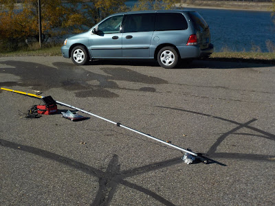
The purpose for including the next several photos in this presentation is to show the rigging I used to capture underwater images on video on my second trip. The bottom two photos are from that video. One can see the relative clarity of the water at the bottom of the river...about 15 or so feet down. I was happy with the experimental results, but now I would need to find the target rock again! Also, on the next trip, sufficient anchorage would be needed, though this would likely cause more water pressure against the pole. Maybe more weight can be added to the tip of the pole where the Sony camera and the extra submersible flashlight had already been attached the second time around. With a solid anchorage attained, we would have a better opportunity of viewing the rock in detail without drifting over it and then having to find it over and over again. So, my strategy for a third attempt will include everything learned from the first two attempts, plus adding the concept of solid anchoring, if possible. Or, maybe a professional diver could be added to the next attempt, along with anchorage....


"Below Stanton is DEAPOLIS (caps in the original), marked by a single grain elevator, all that remains of another of the towns that sprang up along the Missouri, flourished, and declined with the steamboat trade...old residents tell the story that in the summer of 1894 the river at Deapolis was extremely low, exposing a huge boulder in the center of the stream. An interested group made their way to the stone, and found it carved with peculiar markings they were unable to decipher. Before leaving, they added the date of their visit to the inscription. Forty years later, the river stage was again low enough to bring the stone above water, and a second party visited it, and found the same undecipherable markings, as well as the carving of the 1894 party."
Holand goes on to cite several reasons why he thinks the rock bears Norse runes. One reason is because in the past Mandan Indians were situated in the exact same spot as where the strange rock is located. Another reason is because the so-called "Verendrye Runestone" was discovered in North Dakota too, and this small stone is thought to possibly have had runes carved into it. Additionally, the local settlers indicated that the inscription was carved, which would further indicate an iron chisel being used, something Native Americans would not have possessed.
It seems possible to me that one of many "half-century droughts" in the past may have exposed the large rock to a medieval-era Norse carver, even before the two later groups of settlers found it exposed by much later droughts. If so, this may reveal a possible medieval Norse/American Indian connection, which could in turn help to explain the peculiar genetic makeup of the Mandan Indians.


http://www.lewisandclarktrail.com/section2/ndcities/BismarckMandan/villagemap.htm
http://www.digitalhorizonsonline.org/digital/collection/uw-ndshs/id/1245


I believe I may have discovered that the described rock may still be in the water, exactly across from where Old Deapolis was situated by the railroad track by the river. On the first trip I made to the area, while using modern equipment, I ended up with a depth finder screen shot of what appears to be a large rock. In other words, sonar found an "anomaly," almost certainly a large boulder, submerged in about 17 feet of water, directly across from the former site of both a Mandan village and the vanished town of Deapolis. The fisherman boat-pilot I hired was somewhat familiar with the bottom of the river in this area and he was surprised to see what appeared to be a large rock, perhaps 3 or so feet high by several feet long, sitting on a ledge near the main channel. The channel was about 22 feet deep at the spot. It's possible that the river was only several feet deep during severe droughts, leaving the rock in a foot or two of water with the shrunken down river flowing in an adjacent channel--perhaps only several feet deep. If the rock was sitting on a ledge in a few feet of water with the main channel flowing next to it, this may have made the rock appear to be in the middle of the river, which was reported.
On this, my first trip, the river was riled by the wind and we were not able to get any good camera images of the apparent rock seen on the depth-finder. I was determined that on my next trip, better camera techniques might be applied to the situation, perhaps using a long pole to reach down with better lighting and a more stable video camera. So, I revisited the site again on October 22nd, 2016, hoping to obtain photos of an old inscription--a message--carved onto the rock. But, we had trouble relocating it, even though the weather this time was stunningly beautiful...low wind, clear blue sky and temps in the mid-sixties. There had been no previous rain, so the water clarity was exceptionally good. This time, however, we did see on the depth-finder a strange-looking image of a rock close to where the other one was, having two "pillars" a few feet high, tapering narrower going up from thicker bases. Of course, we didn't know whether the message was carved on top of the rock or on a side, but if the rock was only a few feet high, it seems likely that the inscription may have been carved on top--like on the Narragansett Bay, MA runestone.

The purpose for including the next several photos in this presentation is to show the rigging I used to capture underwater images on video on my second trip. The bottom two photos are from that video. One can see the relative clarity of the water at the bottom of the river...about 15 or so feet down. I was happy with the experimental results, but now I would need to find the target rock again! Also, on the next trip, sufficient anchorage would be needed, though this would likely cause more water pressure against the pole. Maybe more weight can be added to the tip of the pole where the Sony camera and the extra submersible flashlight had already been attached the second time around. With a solid anchorage attained, we would have a better opportunity of viewing the rock in detail without drifting over it and then having to find it over and over again. So, my strategy for a third attempt will include everything learned from the first two attempts, plus adding the concept of solid anchoring, if possible. Or, maybe a professional diver could be added to the next attempt, along with anchorage....


The Vikings has an excellent diver we can use!
ReplyDeleteHe was with us at Lightning Lake and we did find a few great things submerged in water.
We have to decide if we shall do it again when it's crystal clear and film deep below.
Cheers, Bob!
Nice job on all fronts!
Awesome article...
ReplyDeleteViking Brother has a diver up in MN...
He covered Lightning Lake for us...many things submerged.
The Viking Team can meet up and be of help!
VBPete
Thanks for letting me know, VBPete. I'm looking forward to possibly working with you on this very worthwhile project! I'll be in touch with you about it....
Delete